Advanced Aerial Surveying, Photography, and Videography in Cleveland
Aerial Perspective for Ohio Operations
Cleveland Helicopter Charters delivers comprehensive aerial survey solutions across Ohio, capitalizing on the helicopter's unique low-altitude and hover capabilities. We facilitate advanced data acquisition, including magnetometer and electromagnetic surveys, LiDAR, and precise GIS mapping for critical infrastructure and resource management. Furthermore, our specialized aerial filming services integrate cutting-edge cinematography and photography technology. Whether requiring gyro-stabilized platforms or simply a door-off configuration for handheld precision, we tailor solutions to your project's exacting specifications. For unparalleled aerial data capture and visual media production over Ohio's diverse landscape, our capabilities are expansive and precisely executed.
Aerial
Surveys
LiDAR, GIS Maps, FLIR, HD Video & More
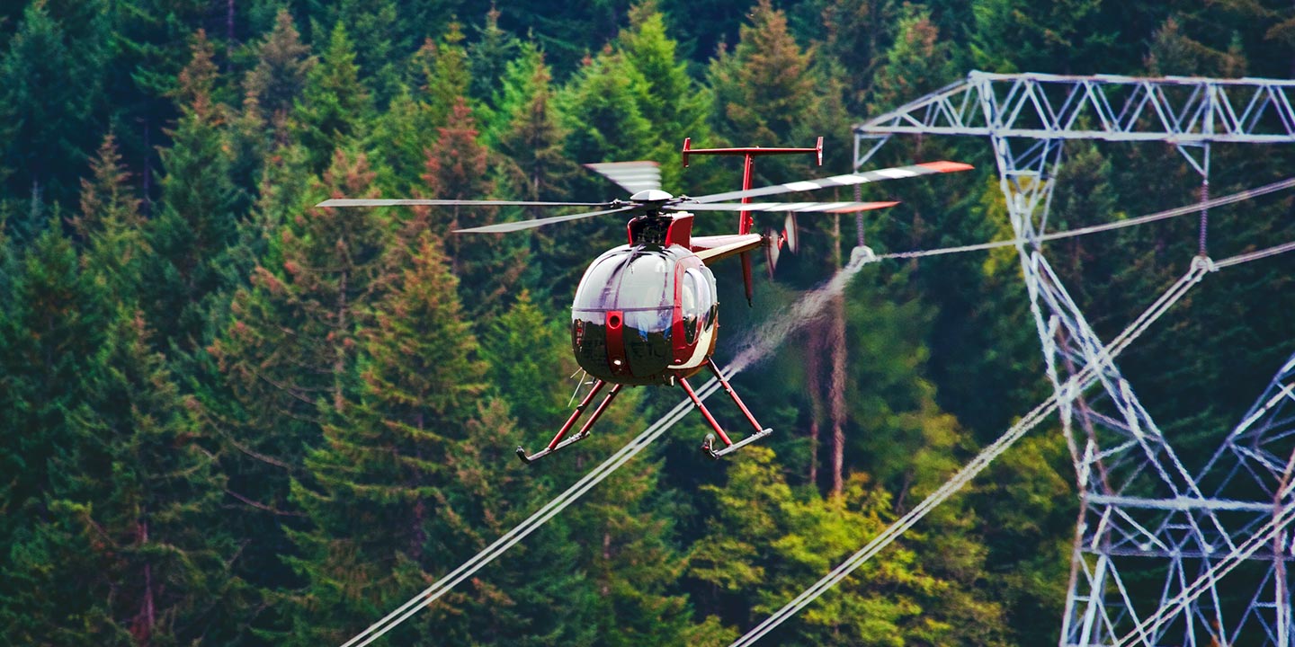
Cleveland Helicopter Charters provides essential aerial support for critical infrastructure. Our services encompass comprehensive pipeline surveys, rigorous Right-of-Way (ROW) inspections, and efficient transmission line patrols across Ohio. We meticulously provision the appropriate rotorcraft, specialized equipment, and skilled operational support necessary to execute your infrastructure projects with precision and reliability.
High Tech Results
The Top Pilots in Ohio, Today's Technology... Maximum Results.
Call 1-866-826-4826 Now!
Cleveland Helicopter Charters provides the tools needed to complete your land surveys, utilizing the right equipment to provide the aerial photos that are often needed.
Precision aerial surveys simplify complex commercial projects, facilitating accurate Right-of-Way (ROW) and site inspections, comprehensive topographical data acquisition, and high-definition imagery capture across Ohio. Helicopters are unparalleled for assessing the diverse Ohio terrain; from critical pipeline leak detection and transmission line anomaly identification to detailed property surveys via video and photography. Cleveland Helicopter Charters specializes in developing bespoke photographic and remote sensing operations. We custom-fit each mission to maximize both technical efficacy and financial efficiency, ensuring superior data acquisition and actionable results for your enterprise.
Helicopters offer distinct operational advantages for aerial surveying compared to fixed-wing aircraft. Their superior maneuverability allows for significantly lower and slower flight profiles, which is crucial for detailed data capture. While FAA regulations mandate fixed-wing aircraft maintain a minimum altitude of 1,000 feet above obstacles, helicopters can operate at much lower altitudes, providing granular detail. This capability enables precise inspection of challenging or hazardous zones, furnishing engineers and project managers with invaluable, otherwise inaccessible, perspectives for comprehensive analysis and informed decision-making across Ohio.
There is no better way to conduct your visual survey, animal population counts, soil drainage analysis, ROW inspections, pipeline and transmission line inspections, and geographical surveys.
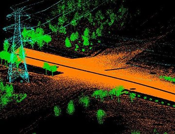
LiDAR Imaging
Light Detection and Ranging, or LiDAR, is a remote sensing method used to examine and measure Ohio topography as well as objects, like vegetation, upon it.
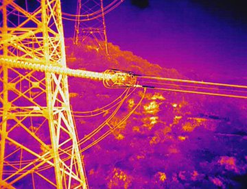
Infrared Imaging
Thermographic IR cameras are used to detect radiation in the long-infrared range of the electromagnetic spectrum and produce images of that radiation, called thermograms.
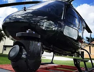
HD Video Gimbal Capture
Modern HD and 4K cameras can be mounted to helicopters, using the proper STCs, with a gimbal to stabilize photos & videos for detailed results.
Precision Aerial Filming and Professional Videography Services
For expert camera work in the Cleveland Sky
Get a Fast, free QuoteCleveland Aerial Cinematography
Cleveland Helicopter Charters provides unparalleled access to professional-grade aerial cinematography resources throughout Ohio. We facilitate custom production shoots by leveraging advanced technology, including sophisticated gyro-stabilized camera mounts such as Tyler Mounts, Wesscam, Cineflex, Pictorvision, and SpaceCam. These platforms integrate seamlessly with high-fidelity specialty cameras like Cineflex HD, RED Epic, Arri Alexa, and even cutting-edge 3D and experimental systems. Our capabilities support all facets of your production goals, from dynamic air-to-air sequences to precise ground-to-air perspectives. Experienced operational support collaborates closely with your aerial Directors of Photography and directors to achieve the exact visual results required for your project. Specializing in helicopter support for both still and motion photography, Cleveland Helicopter Charters is equipped for nearly every media-related operation across Ohio. This includes feature films, television productions, documentary shoots, impactful promotional videos, commercials, specialized aerial props, critical relief work for broadcast networks, and comprehensive coverage of historical events and major sporting spectacles, all utilizing a diverse fleet of helicopters tailored to specific production demands.
Call Us Today at 1-866-826-4826 for a Free Quote
Contact Us
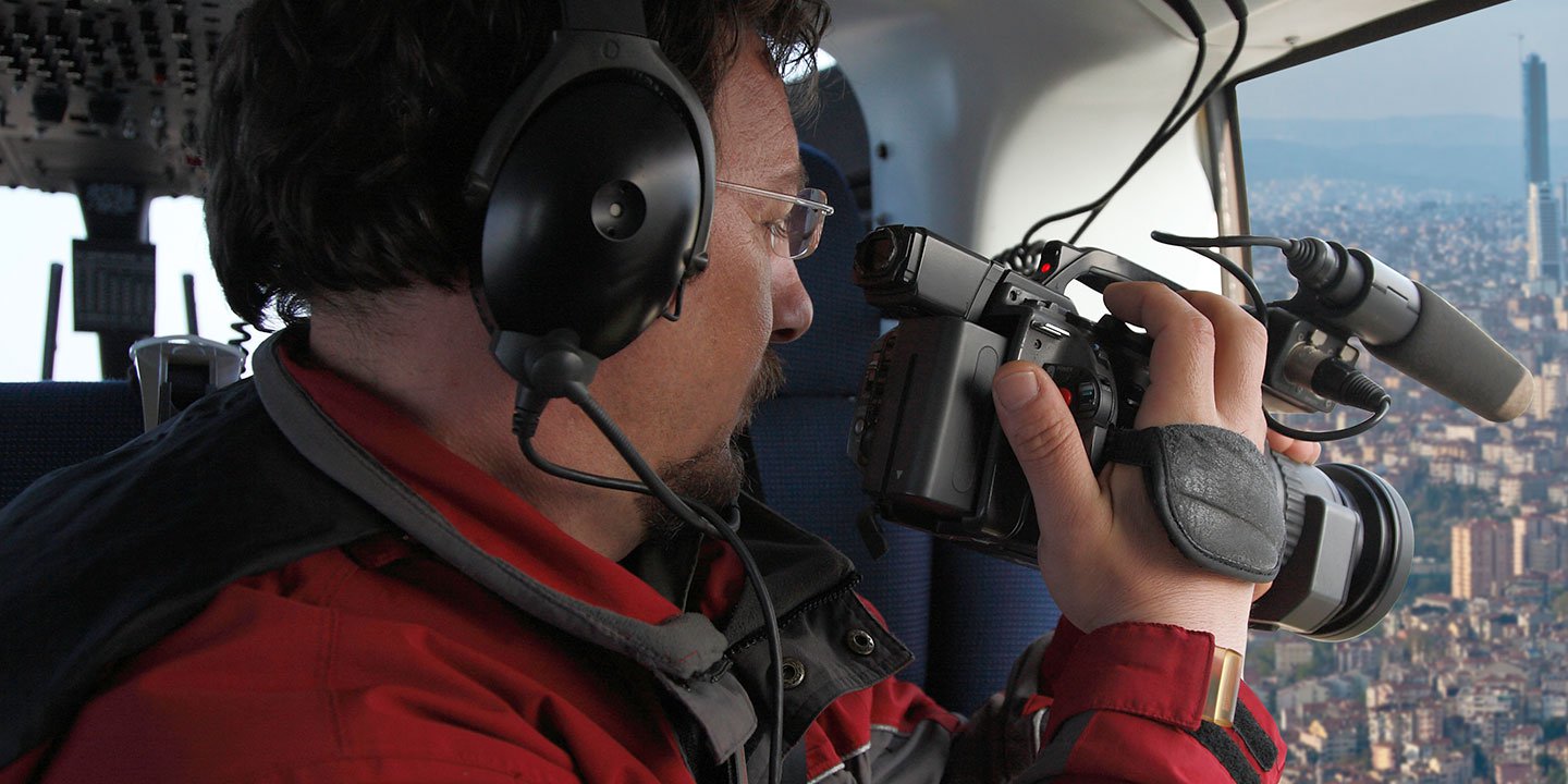
Aerial Photos
Hand-held or Mounted OpTions in Cleveland
We will help you get the right equipment for your aerial photography project! Call 1-866-826-4826 today to get a fast, free quote.
The Most Options for Photography
Ohio's breathtaking landscapes and urban panoramas are optimally revealed and captured from an aerial perspective. Cleveland Helicopter Charters offers bespoke aerial photography charters meticulously designed to translate your creative vision into stunning imagery. Our services are tailored to exceed professional expectations, ensuring every detail you envision is precisely documented from above. We provide cost-effective aerial photographic opportunities throughout Ohio, catering to diverse needs. Many helicopters can be configured for door-off operations, ideal for handheld photography projects, while advanced gyro-stabilized mounts are available to provide superior stability and precision for more demanding cinematic and photographic endeavors. Contact us to discuss the optimal setup for your next aerial shoot.
Superior Service
Every one of our customers gets a dedicated helicopter expert to assist with flight plans, tech loadouts, production logistics, project schedules, and other demands.
Over 500 Aircraft
Our network of direct air partners extends well beyond Cleveland, Ohio. This allows us to offer a wide range of solutions for even the most sophisticated projects.
The Best Equipment
From high-tech sensors like LiDAR, FLIR, and GIS to HD cameras and movie production gimbals, we're here to make your job as easy as possible.